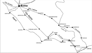
Remarks of the route
It would apparently seem easy to re-discover the itinerary long Appia road today, the “ Regina viarum“, given the large amount of existing texts, articles, memories and catalogues of exhibitions.
But only one person has so far claimed (1) to have covered the whole distance: Francesco Maria Pratilli (1689-1763) (p11 – Pratilli) who describes it in his “Della Via Appia riconosciuta e descritta da Roma a Brindisi”, published in 1745.
The above mentioned sequence of segments (r01 – Radke and l10 – Lugli) raises discussions in relation to the following areas:
1. From Minturno to Capua: the question is whether it passed first by Sessa Aurunca and then by Mondragone.
2. From Mirabella Pass to Bisaccia: the question is whether it passed long the Ufita river and then went up to La Toppa Plain or along the Ufita and Ofanto rivers watershed (q11 – Quilici).
3. From Palagiano to Oria: discussions are made on the trail and construction of the two sections, the one going North of “Mar Grande” and the one that crosses Taranto.
Undeniably, the farthest Appia road proceeds, the more difficult it becomes to identify the original trail.
Up to Benevento, the only question is about the crossing of Ager Falernus (plain of Carinola) but the itinerary is often clearly visible. From Benevento on, there are no traces anymore.
It is nonetheless true that the Ponterotto on the Calore river , just before Mirabella Pass, witnesses the itinerary of Appia road, just as much as the Santa Venere Bridge on Ofanto river before Melfi and the bridge on Gravina Gennarini before Taranto. Except for this, nothing else cam be claimed as effective evidence.
———-
Note 1: just after the publication of the work, Gesualdo Erasmo (g04 – Gesualdo) wrote “Osservazioni critiche sopra la storia della Via Appia di F.M. Pratilli”
| segment | mp | MODERN NAME | ANCIENT NAME | NUM. COORDINATES | quota m | MUNICIPALITY | DISTRICT | REGION |
|---|---|---|---|---|---|---|---|---|
| (mp = 1.482 m) | ROMA Campidoglio | URBE | 41.893333, 12.483000 | 22 | ROMA | ROMA | LAZIO (IT) | |
| 00 - link | IX | ROMA GRA - exit APPIA | URBE | 41.812395, 12.572565 | 81 | ROMA | ROMA | LAZIO (IT) |
| 01 - link | VII | Sepulchre of Emperor GALLIENO | AD NONUM I | 41.790960, 12.589050 | 132 | ROMA | ROMA | LAZIO (IT) |
| 02 - link | III | FRATTOCCHIE | BOVILLAE | 41.766655 12.616553 | 132 | MARINO | ROMA | LAZIO (IT) |
| 03 - link | IV | ARICCIA | ARICIA | 41.717000, 12.671700 | 328 | ARICCIA | ROMA | LAZIO (IT) |
| 04 - link | V | Mount CAGNOLETTO | SUBLANUVIO | 41.692600 12.704500 | 395 | GENZANO DI ROMA | ROMA | LAZIO (IT) |
| 05 - link | IX | CISTERNA DI LATINA | AD SPONSAS | 41.593780 12.832690 | 77 | CISTERNA DI LATINA | LATINA | LAZIO (IT) |
| 06 - link | III | TRE TAVERNE | TRES TABERNAE | 41.564722 12.871111 | 49 | CISTERNA DI LATINA | LATINA | LAZIO (IT) |
| 07 - link | VI | TOR TRE PONTI | TRIPONTIUM | 41.507400 12.945328 | 13 | LATINA | LATINA | LAZIO (IT) |
| 08 - link | IV | BORGO FAITI | FORUM APPI | 41.466650 12.997800 | 8 | LATINA | LATINA | LAZIO (IT) |
| 09 - link | VIII | MESA | AD MEDIAS | 41.385300 13.102300 | 5 | PRIVERNO | LATINA | LAZIO (IT) |
| 10 - link | VII | Shrine of FERONIA | LUCUS FERONIA | 41.310600 13.200000 | 5 | TERRACINA | LATINA | LAZIO (IT) |
| 11 - link | III | TERRACINA | TARRACINA | 41.291855 13.248700 | 39 | TERRACINA | LATINA | LAZIO (IT) |
| 12 - link | XII | FONDI from North | FUNDI | 41.358889 13.426667 | 15 | FONDI | LATINA | LAZIO (IT) |
| 13 - link | XIV | FORMIA | FORMIAE | 41.258333 13.605833 | 41 | FORMIA | LATINA | LAZIO (IT) |
| 14 - link | XVIII | MONDRAGONE | SINUESSA | 41.149335 13.848825 | 9 | MONDRAGONE | CASERTA | CAMPANIA(IT) |
| 15 - link | XXIV | CAPUA | CASILINUM | 41.109800 14.208500 | 32 | CAPUA | CASERTA | CAMPANIA(IT) |
| 16 - link | IX | VILLA GALAZIA | CALATIA | 41.042778 14.361111 | 51 | MADDALONI | CASERTA | CAMPANIA(IT) |
| 17 - link | XV | ARPAIA | CAUDIUM | 41.036111 14.546944 | 281 | ARPAIA | BENEVENTO | CAMPANIA(IT) |
| 18 - link | XII | BENEVENTO | BENEVENTUM | 41.133333 14.766667 | 118 | BENEVENTO | BENEVENTO | CAMPANIA(IT) |
| 19 - link | XV | Pass of MIRABELLA | AECLANUM | 41.053889 15.013889 | 432 | MIRABELLA ECLANO | AVELLINO | CAMPANIA(IT) |
| 20 - link | XLIII | Bridge of SANTA VENERE | PONS AUFIDI | 41.073889, 15.545278 | 220 | MELFI | POTENZA | BASILICATA (IT) |
| 21 - link | XXIV | VENOSA | VENUSIA | 40.961111, 15.816667 | 417 | VENOSA | POTENZA | BASILICATA (IT) |
| 22 - link | XXXVIII | GRAVINA IN PUGLIA | SILVIUM | 40.817222, 16.413889 | 346 | GRAVINA IN PUGLIA | BARI | PUGLIA (IT) |
| 23 - link | XL | PALAGIANO | AD CANALES | 40.579167, 17.036667 | 40 | PALAGIANO | TARANTO | PUGLIA (IT) |
| 24 - link | XXX | Farmhouse GALEONE from South | MESOCHORUS | 40.485278, 17.432500 | 78 | TARANTO | TARANTO | PUGLIA (IT) |
| 25 - link | XXX | BRINDISI | BRUNDISIUM | 40.641111, 17.947500 | 7 | BRINDISI | BRINDISI | PUGLIA (IT) |
| 26 - link | XII | Junction Variant 1 FONDI from South | FUNDI | 41.308051, 13.202497 | 6 | FONDI | LATINA | LAZIO(IT) |
| 27 - link | X | Junction Variant 2 to Farmhouse GALEONE from North | MESOCHORUS | 40.490304, 17.210769 | 19 | TARANTO | TARANTO | PUGLIA (IT) |
Historical notes
The Appia road was built in several instalments between 312 BC and 191 BC to connect Rome to Brindisi, following the advancement of the Roman conquests in southern Italy.
After the defeat of Lautulae (315 BC) near Terracina, which resulted in the defection of Capua during the second Samnitic War (326-304 BC), censor Appius Claudius decided the building of a new road to reach Capua, fast and easy to defend, in the place of the old Latina road, winding and exposed to military attacks.
The first part was built in 312 BC. It started in Rome in Porta Capena inside the Servian walls (near “Circo Massimo”) and ended in Formia.
The second part was built in 307 BC up to Capua, which thus could be reached in 132 mp (milia passum). 1 m(ilia) p (assus) = 1482 m
In 268 BC, after Pirrus defeat (275 BC), the road was prolonged of 32 mp up to Benevento and then through Venosa and Taranto it reached Brindisi in 191 BC, after the Roman conquest of Messapia and Salento.
Thus the road measured a total of 365 mp equal to 540 km.
Only in 109 AC (after four centuries), emperor Trajan created an alternative road from Benevento to Brindisi, the “Via Appia Traiana” with an easier track, modernizing older itineraries built in 221 BC by consuls Minucius Rufus and Lepidus (Minucia road) and by pretor Gellius (Gellia road) in the first century BC, thus obtaining a 28 mp reduction (l10 – Lugli), equal to one day journey.
The Appia road executive project was carried out with new concepts and innovative works, which substantially changed the way to conceive the building of a road, such as:
– the building of long straight stretches: (24 km) from Rome to Genzano, (59 km) from Genzano to Rupe di Leano and others at Minturno and in the Ager Falernus, which implied the building of bridges, viaducts and embankments to overcome natural obstacles;
– the crossing of towns was discontinued;
– the use of systems of drains to overcome the swamps.
The Appia road, which was originally paved with gravel, was later paved with large basalt stone slabs (or ‘basoli’) up to Capua (191 BC). The measures of the road, which would become standard for the other consular roads, were 14 Roman foot (4,15 m) for the gauge, allowing the simultaneous transit of two carriages, and 11 foot (3,25 m) for each side walk, for a total of more than 10 m wide.
About each 10 mp a station (statio) was available for the change of horses (mutationes) and about each 20 miles the station also provided meals and lodging for travelers (mansiones). On the Appia road some the stations coincided with existing villages or they were expressly built for the transport of goods, persons and official mail (cursus publicus) and later became urban centers (see CIL VI, 31338a and CIL VI, 31370)(1).
For such a long and important road, several successive restorations works were necessary; they are witnessed by inscriptions, such as those of:
– Censor L.Valerius Flacco at Formia in 184 BC (Liv. 39.44.6);
– Censor Marcus Aemilius Lepidus at Terracina in 179 BC (Liv. 40.51.2);
– Quaestor Julius Caesar 65-69 BC (Plut. Caes. 5.9);
– Emperor Augustus at Venafro and Benevento on 16-17 BC and 2-1 BC (CIL IX 5986,5989 e CIL IX 5977,5978);
– Emperor Vespasian in 76 AC (CIL X 6812, 6817);
– Emperor Nerva in 97 AC (CIL X 6813,6818,6822,6825,6828,6829,6832,6859,6861-6863,6871,6873);
– Emperor Trajan in II sec AC (CIL X 6849);
– Emperor Hadrian in 127 AC on segment Benevento-Aeclanum (CIL IX 6072,6074,6075);
– Emperor Antoninus Pius at the bridge on the Volturno river at Capua (CIL X 3831);
– Emperor Septimius Severus, who built the Settidotium, the famous monumental facade to mark with a scenic panel the arrival of travelers in Rome, and two columns of African cipolin marble overlooking the Adriatic sea at Brindisi as terminal stones of the Appia road (CIL X 6908 e CIL IX 2122,6010);
– Emperor Caracalla at Fondi (CIL X 6854).
With the building of the Aurelian walls (270-277), the Appia road was discontinued from “Porta Appia” , known today as “San Sebastiano”, so that it is said that Appia road starts at “Porta San Sebastiano”.
Due to its characteristics the Appia road became the main road axis in the commercial relations and for the journeys towards the East.
Along its path, beside the magnificent tombs outside Rome, honorary arcs, villas, houses were added with great monumental splendor so that the Appia road became known as the regina viarum (poet Stazio, second Book of Silvae…qua limite noto Appia longarum teritur regina viarum… ).
The decline of the Appia road starts in the V century in conjunction with the collapsing of the organization of the Roman empire .
The deterioration of the road was further enhanced by lack of maintenance, by the fact that portions became swampy and by the departure of peoples from the plains following the barbarian invasions.
Theodoric (445-525) restored the Decennovius (the name given to the straight portion of 19 miles of Appia road flanked by the canal before Terracina) because it was covered by water.
However, the use of the Appia road was discontinued following the Longobard conquest of Capua in 593.
Until the IX century the segment near Rome was still in use, but following the destructions caused by Saraceni in 946, it was abandoned.
In the following centuries the ancient monuments were transformed by noble Roman families in towers and fortified villages ( for example the Castrum Caetani, which encompassed and thus saved from destruction the tomb of Caecilia Metella).
Moreover, each owner requested a transit fee on his own portion of the road.
This increased the non use of the road and favored the search of alternative ways, such as the “Appia Nuova” road paved by Pope Gregory XIII in 1574 on the existing Asinara road.
During these centuries all monuments and tombs which were at the origin of the splendor and interest of the Appia road were preyed and what remains today is due to the establishment in 1574 by Pope Paul III of the “Commissariato delle antichità per la salvaguardia dei beni storici”.
Finally, in 1568 the Viceroy of Naples, Pedro Afàn de Ribera, Duke of Alcalà carried on restoration works on the abandoned Appia road in the segment of the narrow Itri valley.
Later on Pope Innocent XII (1691-1700) built the “Appia Pignatelli” road to link the Appia road to “Appia Nuova” road.
Pope Pius VI in 1777 restored the segment along the Pontine Marshes before Terracina, which was previously done by Theodoric and which was again covered by water. But during the restoration works the original pavement in basaltic stones was used and therefore was lost.
Today the challenge for the conservation and transmission of the archeological, historical and cultural heritage of the Appia road needs the active participation of all citizens and authorities. After years of discussions, some concrete results were obtained with the establishment of territorial archeological parks along the way from Rome to Brindisi, starting with the “Appia Antica Regional Park” and “Monti Aurunci Regional Natural Park” in Latium, followed in Campania by the “Roccamonfina and Foce Garigliano Regional Park Volcanic Area“.
———-
Note 1:CIL=Corpus Inscriptionum Latinarum
Translation in English by Alfredo Ilardi